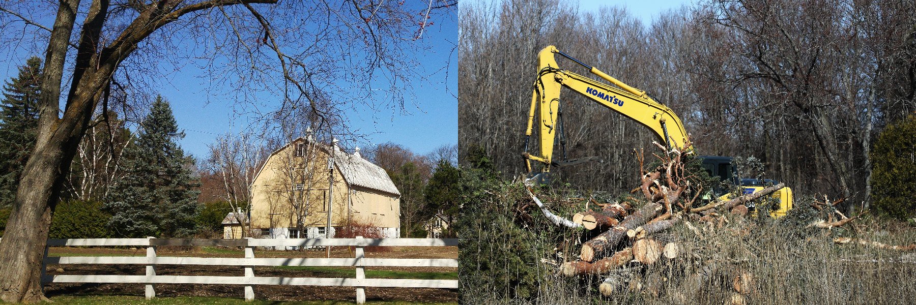
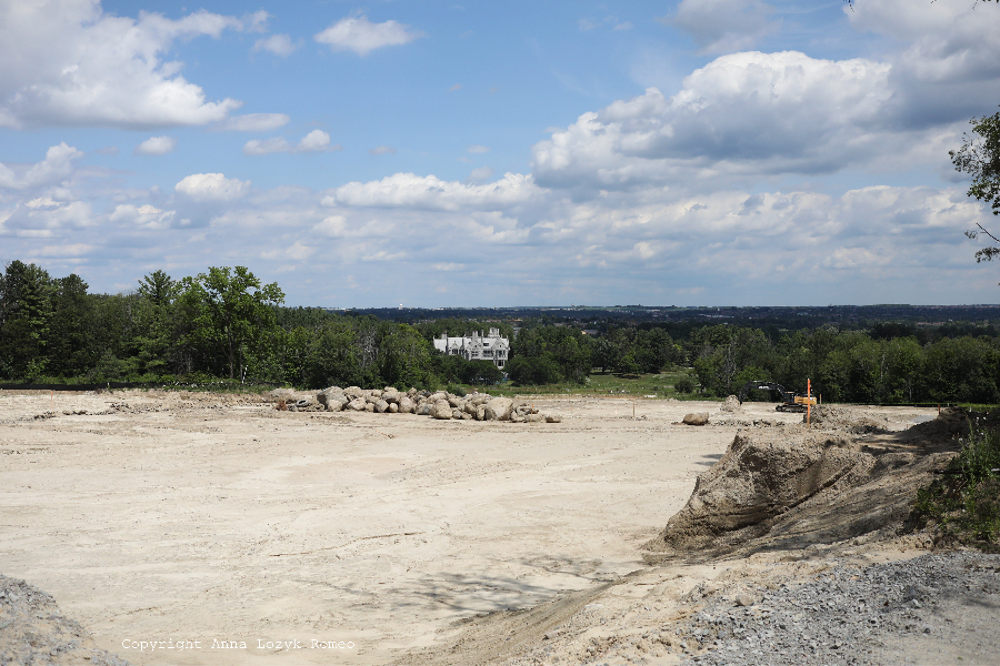
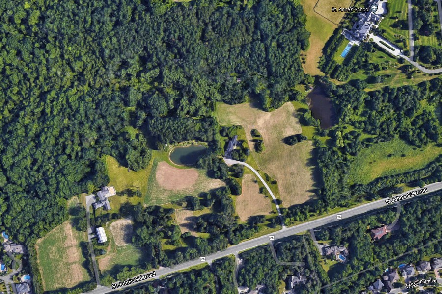
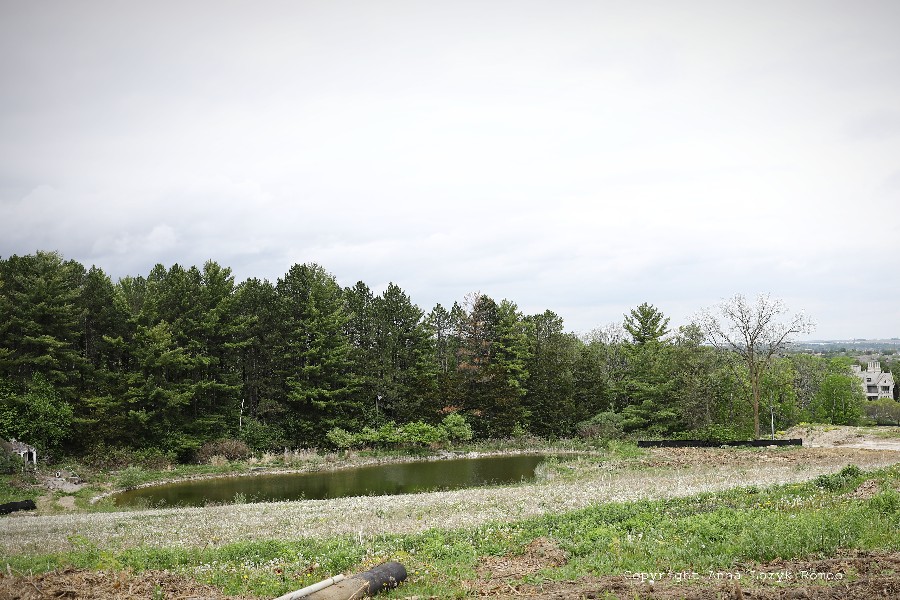
A picture-perfect vista of soft, rolling hills where wild turkey, deer and coyote once roamed has been reduced to a lifeless, razed and barren landscape. The old yellow barn that once stood tall in all its charm, is long gone. So too is the large pond where frogs and newts and other wetland creatures existed undisturbed. To anyone looking northwards these days along St. John’s Sideroad West, between Yonge Street and Bathurst Street, the shocking extent of environmental devastation is crystal clear.
To uncover the full story of how this travesty came to pass, you only have to go as far back as 2019 because, contrary to claims that the destiny of the Shining Hill lands was carved out in this way under the careless watch of a past Council, it was, in fact, the very deliberate decision of our current Council to almost double the density.
When it comes to the environment, actions are what counts, not just words!
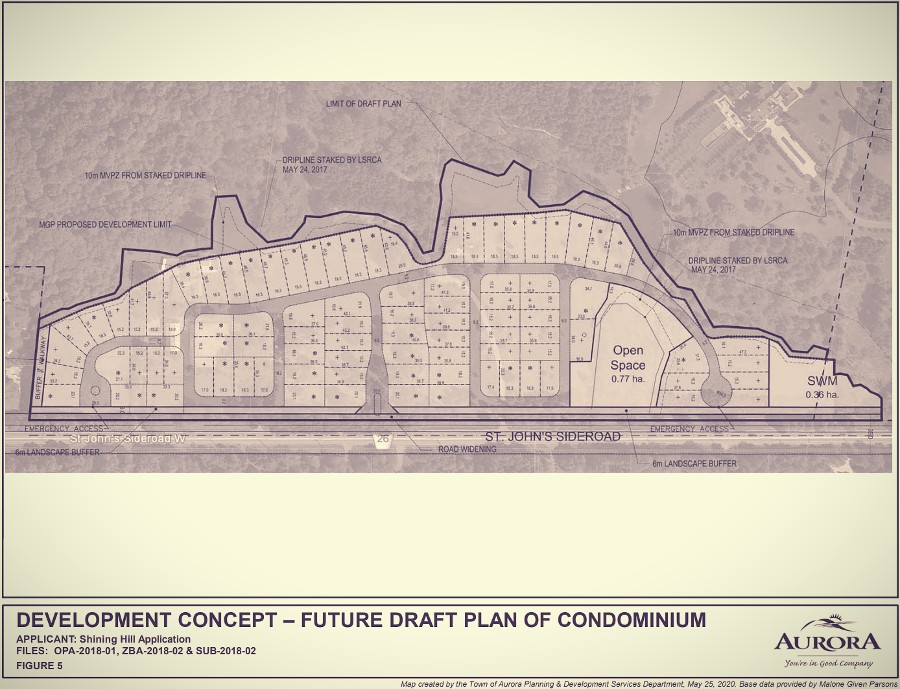
Worse still, Council had no cause to be so generous with these rural Oak Ridges Moraine (ORM) lands because the lands were protected by an Official Plan Amendment 37 (OPA 37) which permitted primarily “low-intensity, environmentally sensitive residential development.” It’s evident from the site plan alone (see below) that this development has turned out to be anything but that.
Watching the June 26th 2019 one and only Public Planning Meeting compared with what later unfolded is simply mind-blowing. The subsequent General Committee meeting on June 16th 2020 and deciding meeting of June 23rd 2020 could well be likened to watching a Council that had had its collective memory erased. Despite the laws of logic and, importantly, our own Official Plan, this highly controversial development was approved, the consequences of which are now in plain sight of even the worst sceptic.
It’s important to mention up front that Councillor Wendy Gaertner fought passionately over the course of three meetings to convince her fellow Councillors of the critical environmental issues at hand but was ultimately the only Councillor who voted against the proposal. In fairness to Councillor John Gallo, who was absent from the first meeting, he made the unfortunate mistake of trusting in staff’s erroneous and incomplete summation of the environmental features at stake. He later apologized to the public for voting in favour of the application and also apologized to Cllr Gaertner “because she raised the red flag and I just didn’t see it.”
As responsible stewards of our environment, we must do everything in our power to minimize the negative impacts of human activity on green space.
Cllr Gaertner, Town of Aurora
Here’s what happened!
“I don’t really know what I can say to convince Council that this is a very inappropriate development for this land.”
Cllr Gaertner, Town of Aurora
June 26th 2019 Public Planning Meeting
What the Public said:
Members of the public raised significant concerns about the appropriateness of the proposal, including concerns about intensification and the impacts of the environment and wildlife. They questioned the loss of trees and forest cover; loss of wildlife habitat; disruption to the animal movement corridor; and the impacts to Tannery Creek and pond.
What Shining Hill’s Consultant said:
- “We are not touching any of the Natural Heritage System, if anything, we are growing it because we cannot touch the actual feature, which is the trees and the wetlands but we also have to add a 30 m buffer to that, and that 30 m buffer will be vegetated and restored so that it expands on the Natural Heritage System.”
- “On the wildlife … we will not be changing that habitat. We would still have all that intact.”
What Shining Hill’s Environmental Report said:
- “The forest located along the northwestern edge of the Subject Property is a high-quality natural heritage feature that provides regional connections to both Lake Simcoe and the north-south regional corridor located to the west. It provides habitat for breeding birds and mammals and meets the criteria of multiple significant wildlife habitats recognized by the OMNRF (Ontario Ministry of Natural Resources and Forestry). It is a large, contiguous feature that requires protection to accommodate the development. The dripline of the woodland was staked May 24, 2017 by LSRCA (Lake Simcoe Region Conservation Authority). The Site Plan includes a variable buffer along the extent of the dripline that ranges from approximately 5 m to 50 m. The length of the dripline and northern development limit is approximately 800 m. A small section of the plan includes grading within the VPZ (Note: ‘Vegetation Protection Zone’ i.e., buffer) and in this area restoration plantings are prescribed to a greater extent. Restoration plantings and habitat enhancement features are prescribed in the following section to enhance the function of this VPZ. Across the site, the average, the buffer is 15 m in width.” Source: Page 60-61, GeoProcess, Environmental Impact Statement (Natural Heritage Evaluation) ST. JOHN’S SIDEROAD, AURORA, April 2020, Project No. P2016-211.
- “To minimize impacts, timing restrictions for removal of trees and construction in water have been recommended. To mitigate the impacts of the development to adjacent features, plantings within all VPZs on key natural heritage and key hydrologic features will be implemented. To compensate for the loss of wildlife habitat in natural features not retained, habitat enhancement features such as bat boxes and turtle nesting beaches will be incorporated into the key features VPZs. Overall, a ‘net gain’ of naturalized linkage along the woodland-wetland-watercourse corridor is intended.” Source: Page 67, GeoProcess, Environmental Impact Statement (Natural Heritage Evaluation) ST. JOHN’S SIDEROAD, AURORA, April 2020, Project No. P2016-211.
What Members of Council said (Cllr Gallo was absent):
- Mayor Mrakas: “I think it is our duty to look at how we can do this properly, address the concerns of our residents, ensure that our Town grows in an appropriate manner and is not overdeveloped. So, we heard loud and clear that if some of the changes and concerns are not addressed it would probably not pass at General Committee.”
- Cllr Gaertner: “Looking at the Official Plan policies and the zoning by-laws that are in place for this area, it’s clear that this area was not intended for intensification of this kind … It is very, very restrictive, what can go on these lands and the vicinity of these lands… this is not an area of intensification … We have to respect the function of the Oak Ridges Moraine.“
- Cllr Thompson: “Typically, we’ve provided as a courtesy and an opportunity for the Applicant to listen to the concerns of the residents, listen to the concerns of those around the table and amend their plans and find a solution that, you know, satisfies all and that’s typically how we’ve done it and so I certainly would like to afford the Applicant that opportunity. Obviously, I think that he’s heard loud and clear the concerns and that this Council has and if there were no changes, I’m sure you can guess how this Council would probably vote but we would leave that for a General Committee meeting.”
- Cllr Humfryes: “To have these homes become more of an executive-type lot is what I see around this area and would also help with the environment in these lands.”
- Cllr Gilliland: “I’m not quite understanding the change in the development in that area other than a positive in the sense that we’re actually allotting more protection. I’m just throwing that out there. I personally would like to see the homes that are being built a little bit larger than the 50, 60 ft lots.”
- Cllr Kim: “We just can’t stop the development because the Province and the other hierarchies within the Province has deemed it that we cannot do that. You know, the main thing that, really, that I see here is whether we’re going to do third residential, whether you bring it down to 50, 60 or 70 ft. Estate homes. That’s the area that is in our purview.”
Rather than voting there and then at the Public Planning (PP) meeting or having the proposal come back to a second PP meeting, Council voted in favour of taking the application directly to a General Committee (GC) meeting, the final comments being:
- Cllr Thompson: “If you think it’s close, great, let’s bring it back to a public planning meeting but if you think it needs significant changes then bring it to a GC meeting and let’s make a decision on this application.”
- Mayor Mrakas: “I’m in favor of moving forward to General Committee and, as stated around the table, just for the public notification, that this does not mean that that the application is being approved, it just means that we’re moving to the next stage to the General Committee and, as I said, if those concerns aren’t addressed then that’s when we would be making a decision and you’ll all be notified at that time.”
- Cllr Gilliland: “We hear you loud and clear. We feel what you’re talking about. I think we need to allow us to move forward and go to a GC and make some decisions and to avoid that appeal so I would be in favor of that.”
- Cllr Gaertner: “I would not suggest sending it to a General Committee. I think this should be denied outright at this Public Planning meeting and the reason is that, well, listen, this is exactly what this Council has been fighting against. We’ve been fighting to protect our Official Plan policies.”
June 16th 2020 General Committee Meeting
Cllr Gaertner began the meeting by reminding Council of what had been agreed at the June 2019 Public Planning Meeting, particularly on the matter of density: “It was finally decided that it wouldn’t go to a Public Planning meeting, it would go to a General Committee meeting. There were many reasons but one was to give the developer a chance to listen to the comments and hopefully to rework the application. So, could I just ask Mr. Waters, the only thing that I can see is that instead of 92 homes, it’s down to 90 homes.”
David Waters, the Planning and Development Services Director gave the following explanation: “The Councillor is quite correct that from a density point of view it’s only reduced by two lots but, in terms of rearranging a lot fabric, the plan now has the large lots flanking St. John’s Sideroad. Those lots are anywhere from 60 to 65 feet frontages and then the smaller lots, relatively speaking, are contained more into the interior and towards the valley.”
Cllr Gaertner further commented: “I don’t really know what I can say to convince Council that this is a very inappropriate development for this land. It is really unheard of that you would have to match what exists across a main street like this. It’s very unusual to have two very important environmental function areas on one property and with our OP saying you’ve not only got to protect them; you have to give extra protection … The lot sizes, though they’ve been changed closer to St. John’s Sideroad, they’ve been made smaller back towards the environmental function area, if what I understand from Mr. Waters is true. And, you know, 92 lots, 90 lots, it kind of ends up with the same intensity. I mean, what are we doing here? Are we trying to protect the environment or are we trying to help developers not protect the environment?”
Cllr Gilliland asked for clarification from staff of her understanding that more protection was being awarded, and received such confirmation from the Planning and Development Services Director: “I just kind of want to clarify with some of the zoning requests that they’re doing. In fact, part of the property, they’re strengthening the environmental protection on part of their property, is that correct?”
Mr. Waters replied: “There is a landform feature that’s on the property that’s identified as an Open Space Block and it’s being protected with a vegetation zone around it as well. That is called a ‘seep’. That’s the only natural feature that’s been identified on the property. It basically is a spring, for lack of a better description and that is being protected with an O2 zoning provision.”
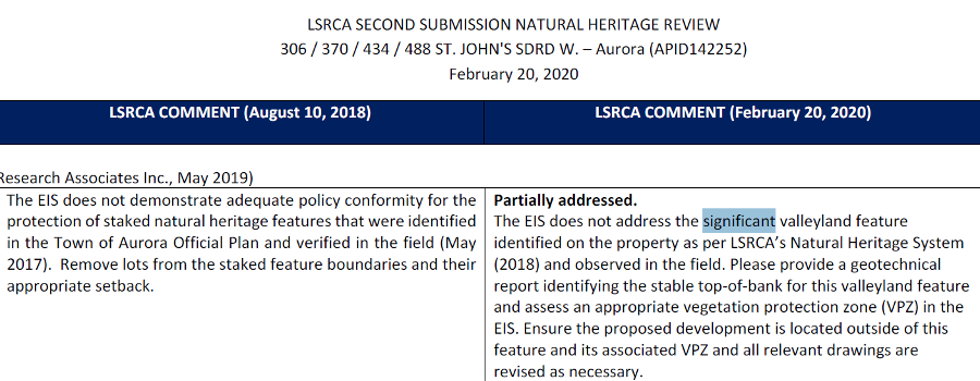
The Director’s Information was Grossly Incorrect
According to the GeoProcess Environmental Impact Assessment report natural features identified on the property, in addition to the Seep are: Significant Woodland, Significant Wildlife Habitat, Unevaluated Wetland, Permanent Watercourse (Tannery Creek), Significant Valleyland, and respective protective buffers (Minimum Vegetation Protection Zones) and Endangered Species Habitat.
Significant Woodland
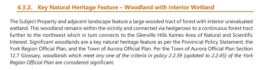
Significant Wildlife Habitat
“The woodland meets the criteria of a number of Significant Wildlife Habitat categories, see Section 6, including woodland raptor nesting and wintering areas, bat maternity colonies habitat, amphibian breeding habitat and woodland area-sensitive bird breeding habitat.“
Source: Page 14, GeoProcess, Environmental Impact Statement (Natural Heritage Evaluation) ST. JOHN’S SIDEROAD, AURORA, April 2020, Project No. P2016-211.
Permanent Watercourse (Tannery Creek)
“4.3.1 Key Hydrological Feature – Watercourse: A tributary of Tannery Creek flows east over the Subject Property through the Aurora (McKenzie) Marsh Wetland Complex (approximately 1.2 km east) towards its confluence with the East Holland watercourse.“
Source: Page 12, GeoProcess, Environmental Impact Statement (Natural Heritage Evaluation) ST. JOHN’S SIDEROAD, AURORA, April 2020, Project No. P2016-211.
Significant Valleyland
Endangered, Rare and Threatened Species Habitat
“As per Schedule E1, the Subject Property is located within a 1km grid marking habitat of Endangered, Rare and Threatened Species.“
Source: Page 10, GeoProcess, Environmental Impact Statement (Natural Heritage Evaluation) ST. JOHN’S SIDEROAD, AURORA, April 2020, Project No. P2016-211.
Oak Ridges Moraine Key Natural Heritage, Hydrologically Sensitive Features, etc.
“Schedule ‘K’ Map 1, ORM Key Natural Heritage Features and Hydrologically Sensitive Features, of the Amendment No. 48 shows the property contains Woodland, Woodlands Minimum Protection Zone, a Permanent/Intermittent Stream with a Streams Minimum Vegetation Protection Zone and potentially containing ORM Endangered, Rare and Threatened Species. These features were staked with the LSRCA on May 24, 2017.“
“Schedule ‘L’ Map 1, Oak Ridges Moraine Landform Conservation Areas shows that the site contains both Complex and Moderately Complex Landform. Schedule ‘M’ Map 1, Oak Ridges Moraine Areas of High Aquifer Vulnerability, shows the property contains areas of High Aquifer Vulnerability.“
Source: Page 10, GeoProcess, Environmental Impact Statement (Natural Heritage Evaluation) ST. JOHN’S SIDEROAD, AURORA, April 2020, Project No. P2016-211.
Whether the seep is being adequately protected is open for debate, given the following:
The Oak Ridges Moraine Conservation Plan (ORMCP) buffer for a seep is 30 m as indicated in the table:
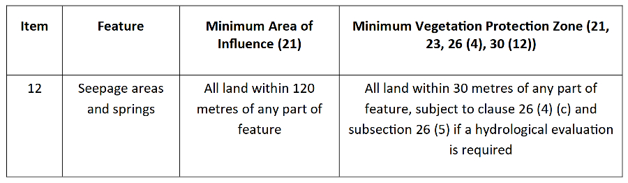
Furthermore 26(4)(c) (Page 46): “Determine whether the minimum vegetation protection zone whose dimensions are specified in the Table to this Part is sufficient, and if it is not sufficient, specify the dimensions of the required minimum vegetation protection zone and provide for the maintenance and, where possible, improvement or restoration of natural self-sustaining vegetation within it.”
Vegetation protection zone for Seep as per Applicant’s environmental report: “b) The seepage Vegetation Protection Zone has been increased to an average of 15 m with no area less than 5 m.“
Source: Appendix A Agency Comments, Page 1, GeoProcess, Environmental Impact Statement (Natural Heritage Evaluation) ST. JOHN’S SIDEROAD, AURORA, April 2020, Project No. P2016-211.
Interesting enough Cllr Kim focused his attention on the “balance” between the environment and “affordable housing”: “… When you can double the density and more affordable housing, you certainly don’t change that equation. Well, I’m oversimplifying it but the underlying facts remain in terms of that delicate balance between environment and affordable housing and those are the decisions that we make.”
Source: Watch at 03:07:15 https://youtu.be/jRAPgugcsmY?t=11235
Perhaps the statement made by Mr. Given, Shining Hill’s consultant during June 2019 Public Planning meeting was not enough to indicate to Cllr Kim that there was nothing affordable about this development. Consultant said: “All intended to be a part of the complex that allows for people in this community and Newmarket to stay in the Town but buy something that they can lock up and leave and go down to their place in Florida or something like that.“
Source: Watch at 00:16:33 https://youtu.be/wzb6BtWKmi0?t=993
Council Ultimately Voted in Favour of the Official Plan and Zoning Changes
Voted in favour: Mayor Mrakas, Cllr Thompson, Cllr Kim and Cllr Gilliland. Voted against: Cllr Gaertner and Cllr Gallo. Cllr Humfryes was absent.
June 23rd 2020 Council Meeting – The Final ‘Nail in the Coffin’
A Last Push for Environmental Protection – Increased Buffers
Sensing that the development was going to be approved by her fellow Councillors, Cllr Gaertner put forward a Motion to increase the buffers protecting the environmental features to 30 m. Cllr Humfryes seconded that Motion.
- Cllr Gaertner: “I’m going to put the Motion on the table, notwithstanding what Lake Simcoe has said, because I think this is our subdivision and I think we’re required to follow the Oak Ridges Moraine Conservation Plan.”
- Cllr Gallo: “Can we please have staff advise on what the discrepancy is between Lake Simcoe being OK and apparently it not complying with the Oak Ridges Moraine Conservation Act?“
- Mr. Waters: “I think the 30 m depends on if it’s a natural feature or not, as defined in the Oak Ridge’s Plan. We work with our partners at Lake Simcoe and, if they wanted a 30 m buffer, they would have asked for it as part of a draft plan condition. That doesn’t mean that through the detailed design work, if additional buffering is required, it will be implemented.”
- Cllr Gallo: “But does it currently comply with the Oak Ridges Moraine Conservation Plan?”
- Mr. Waters: “Yes, in my opinion, it would.”
- Cllr Gallo: “Unless I hear differently, I mean, I don’t know what else to say.”
- Cllr Thompson: “If this amendment were to pass, what would be the impact to the Applicant?”
- Mr. Waters: “It could potentially impact the number of lots they could achieve …”
- Cllr Thompson: “So, this could, in essence, end this application and then they may have to either take this to the OMB (Ontario Municipal Board) or redesign the layout and come back to us?“
- Mr. Waters: “That’s exactly correct, yes, sir.“
Cllr Gallo asked Cllr Gaertner for a page reference regarding the ORMCP (Oak Ridges Moraine Conservation Plan) protective buffer sizes (Key Natural Heritage Features). Cllr Gaertner, in turn, asked the Planning and Development Services Director for his assistance in providing this information as contained within the Planning Report.
- Mr. Waters: “I believe Cllr Gaertner was referring to Appendix G, which is on page 77 of 93, I believe, of R9.“
- Mr. Waters: “It is a six-page chart. I believe Cllr Gaertner may be referring to a buffer that is next to a key natural feature that requires additional buffer protection. In this case, I don’t believe there is one that is next to this proposed subdivision which is why the ten meters has been proposed and accepted by the Conservation Authority.”
- Cllr Gallo: “… I wish I could support this and I wish I could point to something that is telling me that that buffer needs to be there and we’re doing something in error but I can’t see it and I trust staff that this is correct because I have no reason to believe it’s not. There is a natural heritage system there. Whether inside that there’s a natural heritage that requires it, surely someone would have triggered it at some point that mandated that 30 m but I’m at a loss …”
The vote to increase the protective buffers to 30 m FAILED, with only Cllr Gaertner and Cllr Humfryes voting in its favour.
Heritage Evaluation
An interesting side story here. A further motion was put forward by Cllr Gaertner requesting a heritage evaluation of the buildings on site. In response, Council asked the following.
Cllr Kim: “Will this additional report to evaluate the heritage value, will that impact the developer?”
Cllr Gilliland: “I think I logged on when Mr. Waters was explaining that it would not be a problem to go through this process with the developer. Mr. Waters, would you confirm that?”
Council voted in favour, by a narrow 4-3 vote, to have the Heritage Advisory Committee evaluate ‘the existing two homes and the barn on the subject property” for heritage value. The problem with this is that the Town had already issued demolition permits in respect of one of the two homes (no. 488 St. John’s Sideroad) and also the barn. In fact, the barn had apparently already been demolished. According to a Memorandum of June 7th 2021 from the Planning and Development Services Department to the Heritage Advisory Committee, a demolition permit for the barn was issued in May 2019 and it was demolished in January 2020. A demolition permit for the home on 488 St. John’s Sideroad had been issued in May 2020.
The Final Nail in the Coffin
The meeting concluded with the following comments.
Cllr Gaertner: “Mr. Mayor, does anyone else wish to speak?”
Mayor Mrakas: “Doesn’t look like it.”
Cllr Gaertner: “Everybody may be an ‘environmentalist at heart’ (this is a direct response to an earlier comment made by Cllr. Kim’s that “we’re all environmentalists at heart”), but that needs to be underlined by action. If it is our intent to protect the sensitive functions and features of the Moraine, we would not be approving the subdivision in the proposed density… Developers are looking at their highest and best use of the land. Protecting the Moraine has a very different requirement of highest and best use. Climate change is real. As responsible stewards of our environment, we must do everything in our power to minimize the negative impacts of human activity on green space. In my opinion, if this is approved, we are putting developers’ profits ahead of the needs of the environment and I strongly object.”
All Councillors except Cllr. Gaertner ultimately voted in favour of this development, despite the initial collective grand-standing during the June 26th 2019 Public Planning Meeting.
And here’s the kicker: the number of lots had been reduced by only two, from 92 to 90. The proposal was formally approved by Council on June 23rd 2020 and, ironically, according to the latest Shining Hill’s own marketing, the number of lots is now 91.
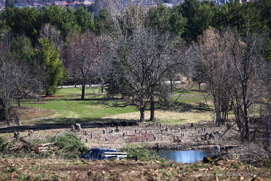
What Really Happened to the Natural Features
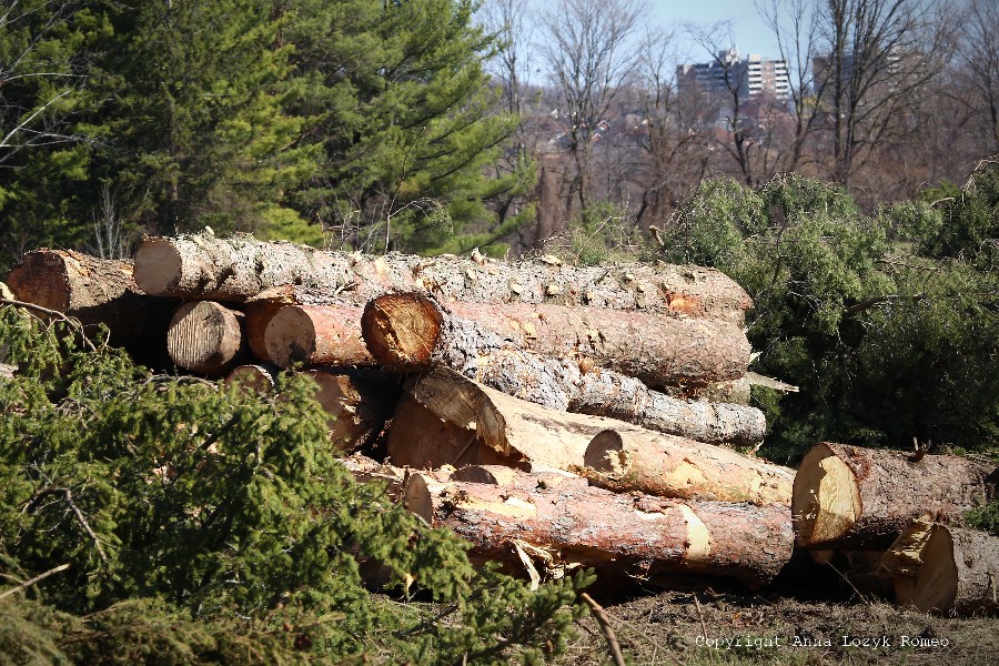
The Shining Hill Phase 2 development site on St. John’s Sideroad west is now under construction. In order to accommodate the 90 (now 91) lots, approximately 500 trees have (according to Shining Hill’s environmental report) been removed and wildlife habitat destroyed.
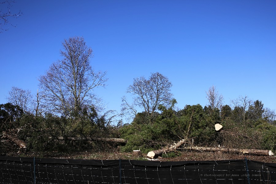
A large pond has been drained, rendering its resident wildlife, at best, homeless. The site plan appears to show two partial lots proposed in its place. Tree loss and removal of ponds was barely even mentioned in the Town’s reports to the public over the course of three meetings: Public Planning, General Committee and Council. One would have to dig deeper into consultant studies to find such details.
In preparation for the new St. Anne’s school and the next phase of residential development, a larger pond beside the school was also approved for removal. Of note, an environmental study produced as part of that next Shining Hill (Phase 3) application (immediately to the east of the Phase 2 lands), describes the pond as potentially containing “sensitive wildlife species”. A Muskrat lodge and two muskrats were also identified in the pond during the same study. Tannery Creek is being re-aligned on the premise that this will improve the Creek’s health in the long-term. However, immediate loss of wildlife habitat will have to occur.
It begs the question, can wildlife, particularly at-risk species such as the Snapping Turtle, recover from such an assault on a local population? The Town’s website comments that the restoration will replicate “natural stream functions if left untouched over time”. Yet, many of Canada’s at-risk species no longer have the luxury of time. Populations are decreasing right now.
Throughout the large construction site, loss of connectivity and habitat function is inevitable, with no guarantees that the sensitive flora and fauna will recover or return.
A substantial amount of grading appears to be going on, despite the fact that disturbance of Landform Conservation Category 1 Oak Ridges Moraine lands must, according to regulation, be kept to a “minimum”.
The final insult is that the protective buffers for the Significant Woodland, Significant Valleyland, Endangered species habitat, Significant Wildlife Habitat and Seep (wetland) have been drastically reduced from the standard widths as per the Oak Ridges Moraine Conservation Plan.
Is this what “environmentally sensitive development” should look like?
Watch full video by Bright Sun Films here: Amazing ABANDONED Home with Infinity Pool
Oak Ridges Moraine Protective Buffers – The Fox in Charge of the Henhouse
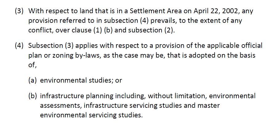
There’s a disappointing caveat within the Oak Ridges Moraine Conservation Plan (ORMCP) which is this: if lands were within a Settlement Area as of April 22, 2002, buffers can be decided as a result of environmental studies. See Section 21(4)(a) below:
However, these environmental studies are carried out by the same environmental firms advocating for their clients, i.e., the developers. It comes as no surprise then, that the buffers ultimately put forward are generally far less than the prescribed buffer widths of the ORMCP, a document that was created to protect the integrity of the Oak Ridges Moraine.
In addition, buffers justified by environmental firms advocating for their client are often applied as an “overall average” which in some cases represents buffers that are as little as 2 meters away from the natural heritage feature. As for Lake Simcoe Region Conservation Authority’s (LSRCA) agreement to these narrow buffers, again, there’s a lot more to that and is a story for another day.
The bottom line is that the buffers protecting sensitive Oak Ridges Moraine lands should reflect the intention of the ORMCP and have been set at 30 m or more for sound reason. With regard to the Shining Hill Phase 2 proposal, the important fact is this: Council could have instructed Shining Hill to go back and re-work its Site Plan, in keeping with the “low intensity, environmentally sensitive development” required by OPA 37. This would have enabled wider buffers and greater protection for the environmental features, in line with our own OP. They didn’t and instead, the density was almost doubled, with thinner buffers and with the smaller lots pushed back towards the valleyland, with all its sensitive environmental features.
Blind-sided
Residents attending the June 2019 Public Planning Meeting would likely have slept well that night, the reassuring words of Councillors still echoing in their heads. They were told that concerns were apparently being addressed and the proposal would come back to GC substantially revised and more acceptable to all.
Yet, when the GC meeting took place in June 2020, the only visible change was a reduction from 92 lots to 90. This minor change clearly did little to address concerns about intensification on these environmentally sensitive lands which, importantly, were never meant to be intensified. The developer’s consultant offered up the fact that the larger lots were now to be positioned on St. John’s Sideroad, with the smaller lots along the valleyland but, as Cllr Gaertner pointed out, repositioning the smaller lots along the environmentally sensitive valley was certainly not the answer.
The warning put forward by some Councillors that delaying Council’s decision would end badly at an Appeal Hearing is questionably flawed in its reasoning. After all, when a municipal Council votes to uphold its own Official Plan, is this not sending a powerful message to the Province that the municipality takes its OP very seriously? Of course, quite the opposite is true when a Council goes against it.
The Take-away Lesson
Attempting to capture the full magnitude of this folly in less than a book’s worth is a mighty challenge but, suffice to say, the Shining Hill Phase 2 approval leaves a shameful stain on Aurora’s proud reputation as a town that values its natural heritage. As we can now see so clearly on St. John’s Sideroad West, something has changed.
The St. Anne’s School application, also a Shining Hill proposal, was approved by this same Council with very little information provided by the Applicant and, already, over 100 trees have apparently been removed to accommodate the new school access road, connecting the school to St. John’s Sideroad. What’s even worse, this massive development is not yet over, with the Newmarket phase already in the bag and with further Aurora phases still to come before Council.
It makes you wonder: is this how other environmentally sensitive applications also been handled? You’d hope not, because critical decisions like these should never be made based on erroneous information, threats of appeal or skewed perceptions of the matter at hand. Let’s not kid ourselves, this proposal was never about ‘affordable housing’. It was, however, about upholding our own Official Plan and the Oak Ridges Moraine Conservation Plan (ORMCP) which protects the “ecological and hydrological integrity of the ORM Area”.
Importantly, the ORMCP takes precedence over municipal Official Plans but, in this case, was given very little credence. Furthermore, the fact that the Conservation Authority supposedly did little to stand in Shining Hill’s way should, in itself, be questioned.
In short, while it’s now too late to do anything about Shining Hill, Phase 2, arguably the most important lesson that comes from this saga is that, if ever there was a time for the public to pay close attention to the election platforms of those soon running for Council, that time is now. When it comes to the environment, actions are what counts, not just words!
References
[1] Town of Aurora Official Plan Amendment 37 (File Type: PDF)
[2] Public Planning Meeting Agenda; June 26th 2019 (File Type: PDF)
[3] Public Planning Meeting Minutes; June 26th 2019 (File Type: PDF)
[4] Public Planning Meeting Video; June 26th, 2019; Starts at 00:06:35 (YouTube)
[5] General Committee Meeting Agenda; June 16th, 2020 (File Type: PDF)
[6] General Committee Meeting Minutes; June 16th, 2020 (File Type: PDF)
[7] General Committee Meeting Video; June 16th, 2020; Delegation; Starts at 00:05:03 (YouTube)
[8] General Committee Meeting Video; June 16th, 2020; Regular Agenda; Starts at 02:41:35 (YouTube)
[9] Council Meeting Agenda; June 23rd, 2020 (File Type: PDF)
[10] Council Meeting Minutes; June 23rd, 2020 (File Type: PDF)
[11] Council Meeting Video; June 23rd, 2020; Starts at 01:07:53 (YouTube)
[12] Oak Ridges Moraine Conservation Plan (2017); (File Type: PDF)
[13] GeoProcess Research Associates Inc., Environmental Impact Statement (Natural Heritage Evaluation); ST. JOHN’S SIDEROAD, AURORA; April 2020; Project No. P2016-211
[14] Beacon Environmental Limited, Natural Heritage Evaluation Shining Hill Lands; City of Aurora; March 2021 – 220166
[15] Phase 2 of Shining Hill Development set to begin; February 19, 2021; Town of Aurora News Release
[16] Heritage Conditions – Shining Hill Subdivision (Phase 2); Town of Aurora Memorandum Planning and Development Services; June 7, 2021 (File Type: PDF)